For A Smooth Journey, An Automated System To Classify Road Surface Quality
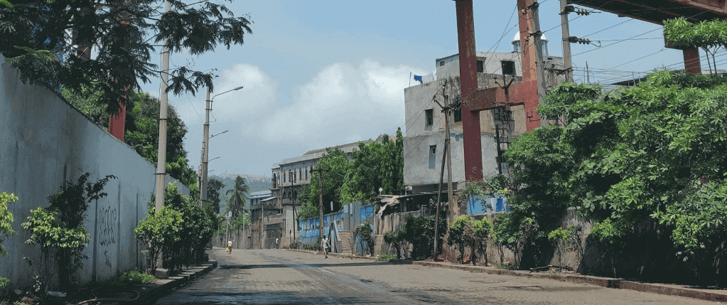
Road monitoring system from IIT Bombay can classify road quality surface using crowdsourced data – Photo by Ananya
Many drivers might have grumbled at their navigation system for leading them through pothole-filled roads under the pretext of the fastest route. It is no secret that the conditions of roads in various parts of our country have seen better days. Even as one section of the road is being repaired, heavy traffic rerouted over another section worsens it. Without a reliable system in place for continuously monitoring road conditions, civic authorities are left to play catch-up with road repairs.
Current techniques employed to survey road conditions are time-consuming and require the use of specialized vehicles that are hard to procure within the limited budget available in developing countries. Instead, RoadCare is a smartphone application that can be used by commuters to share road data while travelling. Based on this data, the app classifies the quality of road sections as ‘good’, ‘medium’ or ‘bad’, depending on their ‘bumpiness’. For example, if a vehicle can smoothly ride over a section of road, even though it has rough patches, the road is classified as ‘good’.
The researchers fed examples of accelerometer and GPS data for ‘good’, ‘medium’ and ‘bad’ roads from the dataset to the algorithm. The algorithm could then puzzle out the connections between the data and the quality of a road surface. When a user runs the RoadCare app, the algorithm uses the learnt connections to make real-time predictions of the road conditions. Additionally, RoadCare finds the direction of travel from the compass information in GPS data, and provides road quality data to the user only for the road they are on and not the opposite lane.
RoadCare works with data collected from phones held or placed in any orientation. “Since we crowdsource the data, the flexibility of having the phone in any direction is important. So, our algorithms are built to be agnostic to phone orientation,” says Prof Bhaskaran Raman from IIT Bombay, who is one of the researchers involved in the study. Further, the researchers have collected data from a variety of phones, ensuring that the algorithm works well regardless of the phone model.
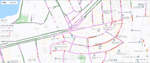
In some cases, the researchers observed that roads in bad conditions were marked as good. This, they say, happened due to the presence of good patches in the road section along with bad, with good count dominating slightly over the count for the bad category. To overcome this problem, they introduced incremental grading on an 11-point rating system — with ‘0’ marking extremely good and ‘10’ marking extremely bad — instead of only three divisions. As the conditions go from good to bad, the colours in the visualization change from dark green to red. This allows for the visualization to convey more nuanced information.
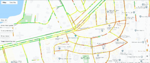
The RoadCare application continuously updates the latest road conditions based on the data provided by the drivers. Hence, it can be used by civic authorities to record the changes in
ratings for the road quality over time. They can discern if the quality of any road has deteriorated and direct their resources in ensuring its timely maintenance. So far, RoadCare has used data given by 25 drivers over fifteen months.
Apply for a PhD at IITs
Apply for a PhD at IITs — the best technology institutions of India
Moreover, RoadCare can suggest alternate routes for a smoother ride. “In many scenarios, commuters may want a smoother route, even if longer, over a faster route,” says Prof Raman. “This could be simply for comfort, or due to health reasons where they cannot withstand rough roads for long, or due for commercial reasons such as transporting fragile equipment. In these cases, having road quality information becomes important.”
As next steps, the researchers are working on improving the integration of RoadCare with Google Maps. “We have recently built a visualization platform which we plan to open to the public, along with the data we collected on Mumbai roads. We also have plans for further improving our algorithms using data from other sensors such as gyroscope,” adds Prof Raman.
| Author(s) of research paper | Saurabh Tiwari, Ravi Nidhi Bhandari, Bhaskaran Raman Dept of Computer Science and Engineering,Indian Institute of Technology, Bombay |
| Contact email | br@cse.iitb.ac.in |
| Title of research | RoadCare: A Deep-learning Based Approach to Quantifying Road Surface Quality |
| Bibliographic Info | Tiwari, Saurabh, Ravi Bhandari, and Bhaskaran Raman. “RoadCare: A Deep-learning Based Approach to Quantifying Road Surface Quality.” In Proceedings of the 3rd ACM SIGCAS Conference on Computing and Sustainable Societies, pp. 231-242. 2020. |
| DOI | https://doi.org/10.1145/3378393.3402284 |
| Funding Information | Ministry of Human Resources and Development, Government of India and Oswal Foundation, Mumbai |
| Article written by | Ananya |
| Image credits | Photo by Ananya |
| Gubbi Labs webpage link |
Related Articles
Everything You Need To Know About Doctoral fellowship in India for ASEAN
Thousands of students every year aspire to do their doctoral programme from the best universities around the world. Research shows 16% of students from ASEAN countries go outside their home country for their PhD research studies. To inspire students from ASEAN countries and to enable access to the best university education and research, the Government […]
Read More
Why Choose India to Pursue Your PhD Programme
A country with a rich history, religious diversity, and hundreds of languages, India is a perfect destination for international students to pursue a PhD programme. India is also the birthplace of an ancient system of education. The education system in India empowers every student to achieve academic excellence and become knowledgeable in their chosen fields […]
Read MoreApply for a PhD at IITs
Apply for a PhD at IITs — the best technology institutions of India


